
भा0 कृ0 अनु0 प0, नई दिल्ली }ारा कृषि विज्ञान केन्द्र-2, सीतापुर को आवंटित विकास ख. डों के नामः-
लखनऊ - के0वीवके0 कटिया: 72 कि0मी0
सीतापुर - के0वीवके0 कटिया: 32 कि0मी0
बिसवाँ - के0वीवके0 कटिया: 13 कि0मी0
| S.N. | Farming System / Enterprise |
|---|---|
| 1 | Crop Production |
| 2 | Crop Production + Sugarcane |
| 3 | Crop Production + Horticulture / Vegetable (Mentha, Tulsa) |
| 4 | Crop Production+ Animal Husbandry+ Fisheries |
| S.N. | Agro - Ecological Situation | Characteristics |
|---|---|---|
| 1 | Zone (5) Central Plane Zone | Crop Production |
| 2 | AES I (Blocks- Maholi, Aeliya) | Sandy loam & loam soil, irrigated through bore well. Major crops Sugarcane & other agricultural and horticultural crops. Dairy is the major subsidiary occupation |
| 3 | AES II(Blocks- Behta, Sakaran, Laharpur, Hargaon, Biswan, Parsendi, Reosa) | Alkaline soil &silty clay soil is existing, this AES is mainly extremely water logged. Main crops are paddy, Sugarcane, Wheat, Turmeric and Menthe |
| S.N. | Soil Type | Characteristics | Area in ha |
|---|---|---|---|
| 1 | Loamy Soil, Sandy loam, Loam | Upland soil, Poor in Soil fertility, Deep water table undulating and eroded soil | 159623 |
| 2 | Silty loam, Silty clay loam | Water logged low land soil, Poor in soil fertility, shallow water table, canal are the major irrigation source | 303599 |
| 3 | Clay loam, Silty clay | Mostly Plain Soil, medium rich in soil fertility, poor drainage | 31942 |
| S.N. | Crop | Area (ha) | Production (Metric Tonnes) | Productivity (q / ha) |
|---|---|---|---|---|
| A | Rabi (2012-13) | |||
| Wheat Sugarcane Barley Toria Lentil Potato Maize Chick Pea Pea Rapeseed - Mustard |
212.016 112.550 0.709 16.880 19.285 3.688 0.004 0.248 2.161 26.840 |
674.635 6111.465 1.431 13.622 15.004 89.961 0.013 0.294 1.699 23.776 |
31.82 543.00 20.18 8.07 7.78 24.39 32.50 11.85 7.86 8.86 |
|
| B | Kharif (2013) | |||
| Paddy Sesame Pigeon Pea Ground Nut Pearl Millet Urd Bean Moong Bean Maize Sorghum Other grain |
169.741 8.497 4.716 2.164 1.874 12.310 0.097 11.176 4.212 0.028 |
430.558 2.141 4.230 1.203 1.519 6.426 0.031 10.762 3.859 0.021 |
25.11 2.52 8.97 5.56 8.11 5.22 3.20 9.63 9.16 7.50 |
|
| C | Zaid (2012-13) | |||
| Maize Moong Bean Urd Bean |
3-4 3 1966 |
468 2 1014 |
14.46 7.19 5.16 |
| Month | Standard Rainfall (mm) |
|---|---|
| January | 2011 : 0.00 2012 : 77.10 2013 : 8.50 2014 : 0.0 |
| February | 2011 : 13.50 2012 : 49.80 2013 : 59.73 2014 : 0.0 |
| March | 2011 : 14.00 2012 : 16.0 2013 : 0.0 2014 : 0.0 |
| April | 2011 : 10.50 2012 : 5.0 2013 : 0.0 2014 : 0.0 |
| May | 2011 : 84.00 2012 : 0.00 2013 : 0.0 2014 : 0.0 |
| June | 2011 : 234.00 2012 : 12.50 2013 : 166.17 2014 : 51.80 |
| July | 2011 : 462.04 2012 : 350.38 2013 : 273.85 2014 : 281.20 |
| August | 2011 : 359.00 2012 : 292.72 2013 : 322.86 2014 : 187.10 |
| September | 2011 : - 2012 : - 2013 : - 2014 : - |
| October | 2011 : - 2012 : - 2013 : - 2014 : - |
| November | 2011 : - 2012 : - 2013 : - 2014 : - |
| December | 2011 : - 2012 : - 2013 : - 2014 : - |
| Total | 2011 : 1177.04 2012 : 803.5 2013 : 831.11 2014 : 520.1 |
| Category | Population | Production | Productivity |
|---|---|---|---|
| Cattle | |||
| Crossbred | 20197 | - | - |
| Indigenous | 587364 | - | - |
| Buffalo | 509104 | ||
| Sheep | |||
| Crossbred | 0 | - | - |
| Indigenous | 5364 | - | - |
| Goats | 507151 | - | - |
| Pigs | |||
| Crossbred | 1288 | - | - |
| Indigenous | 44860 | - | - |
| Rabbits | |||
| Poultry | |||
| Hens | 157319 | - | - |
| Others | 143296 | - | - |
| Improved | - | - | - |
| Ducks | - | - | - |
| Turkey and Others | - | - | - |
| Horse | 177 | - | - |
| Fish | |||
| Marine | - | - | - |
| Inland | 18.81 ha | 100.00 | 23.12 |
| Prawn | - | - | - |
| Scampi | - | - | - |
| Shrimp | - | - | - |
The Sitapur district is situated in central plane at 27°.54’- 27°.60’ N and 80°.18- 81°.24’ E at 100-150 MSL. The topography of the district is mostly planed, but large area comes under low land that is popularly known as Jheels. The ICAR allotted north-east side of the district to KVK, Sitapur-II, which is covered by three major rivers (Gomti, Chowka, Ghaghra) and their tributaries namely Sarain, Pirai, Gond, Godia, Kevani, Ikharia,comes from the Himaliyan range and every year there is occurrence of flood make a typical undulated area known as Ganjar.Average annual rainfall of the district is 989 mm. District have mainly Matiyar, loam, clay,bhoodtype of soils. Agriculture is the main and important occupation of the district. Wheat, Paddy and Urdare the main crops whereas Sugarcane, Mustard, Mentha and Tulsa are the main cash crops. Main horticultural crops are mango, Banana,Papaya,Guavaand Beretc.Farmers are also engaged in vegetable growing e.g. tomato, brinjal, okra, cole crops, cucurbits and leafy vegetables. Potato and vegetable pea is also grown in large area. Buffalo rearing and goat keeping are important component of the animal husbandry. Mostly milk is collected by co-operative processing units and to some extent milk is processed in the form of Deshighee, paneer, khoya.
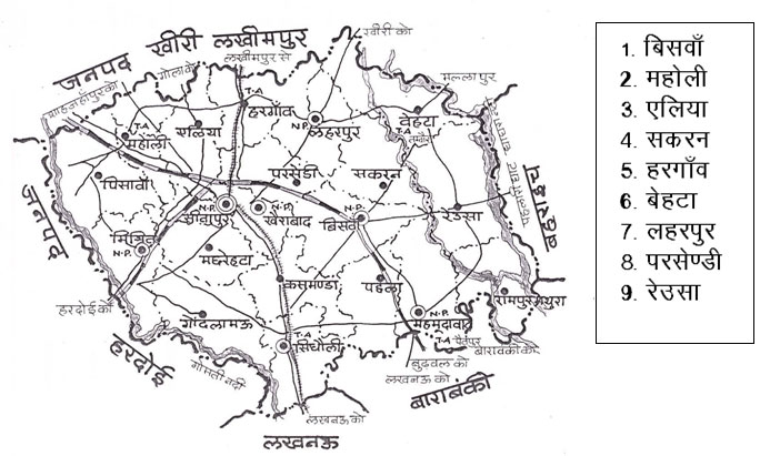
There are three categories of the farmers in the district namely Resource Rich, Resource Poor and Landless Labourers. On the basis of the topography, soil types and irrigation availability, the district may be divided into two major Agro-Ecological Situations i.e.AES-I((Blocks- Maholi, Aeliya)and AES-II.(Blocks- Behta, Sakaran, Laharpur, Hargaon, Biswan, Parsendi, Reosa).
| S.N. | Particulars | No. / Unit |
|---|---|---|
| 1 | Geographical area (Km.2) | 5743 |
| 2 | No. of Tehsil | 7 |
| 3 | No of Blocks | 19 |
| 4 | No. of NyayPanchayat | 209 |
| 5 | No. of Gram Sabhas | 1329 |
| 6 | No. of Revenue Villages | 2348 |
| 7 | Population (In Thousands) | 3620 |
| 8 | Rural Population (In Thousands) | 3187 |
| 9 | Urban Population (In Thousands) | 433 |
| 10 | Literacy (%) : Male Female |
48.3 60 34.6 |
| 11 | Average Family Size Rural area (No.) Urban area (No.) |
6.1 6.0 6.8 |
| 12 | Average Annual Rainfall (mm) | 989 |
| 13 | Temperature (0C) Highest Lowest : 6 |
- 43.34 6 |
| 14 | Size of Land Holding (ha) : Marginal (-1 ha) : b. Small (1-2 ha) Medium (4-10 ha) Large (More than 10 ha) Cropping Intensity (%) |
- 186975 120808 96315 57247 142.7 |
| S.N. | Particulars | Area (ha.) |
|---|---|---|
| 1 | Total reported area | 557610 |
| 2 | Forest Area | 5815 |
| 3 | Banzar Land Situated for Agriculture | - |
| 4 | Current fallow Land | 38873 |
| 5 | Other fallow Land | - |
| 6 | Usar and Uncultivated Land | 5715 |
| 7 | Land used Other Than Agriculture | 60779 |
| 8 | Orchard Tress to Shrubs | 51 |
| 9 | Net Sown Area (in Thousand ha) | 432 |
| 10 | Area Sown in (ha) Kharif Rabi Zaid |
- 325315 279662 43254 |
| 11 | Net Irrigated Area (in Thousand ha) | 371 |